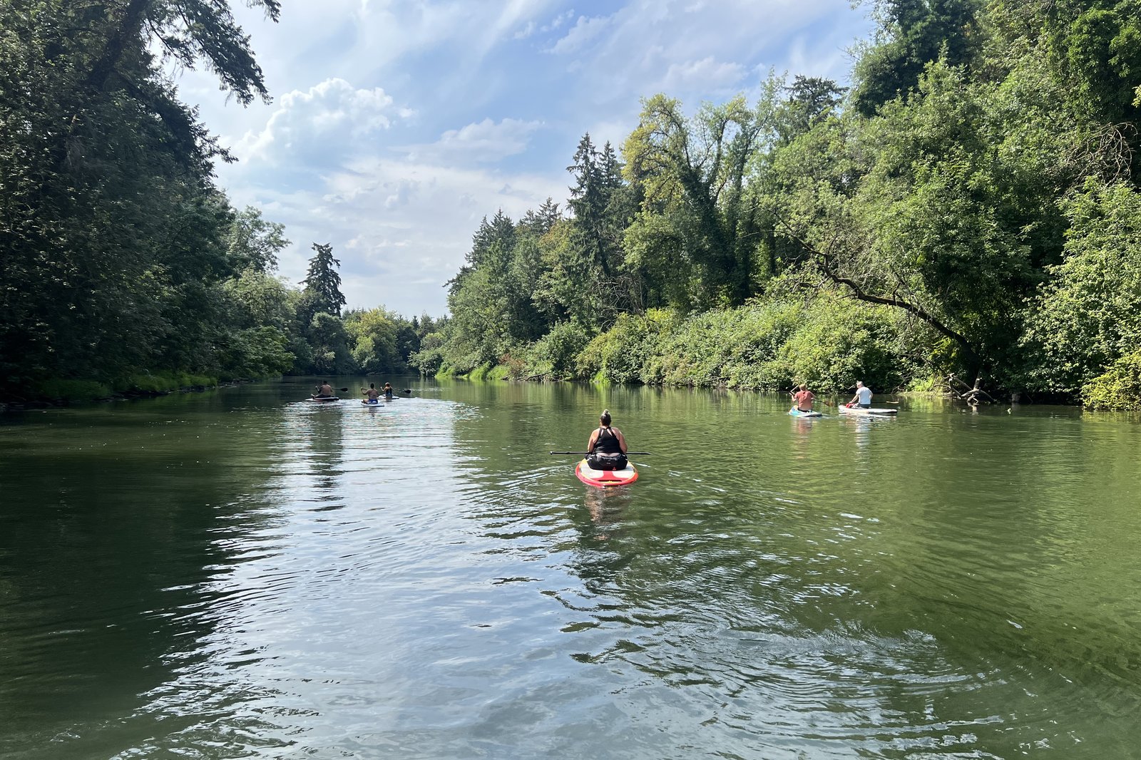
In the second half of the summer, once the Tualatin River has warmed and settled, Jen and I paddleboard from a small ramp in Rivergrove. We carry our boards down a short concrete slope at the end of a residential street. It is the Leonard and Edith Stark Boat Ramp, about 250 feet from the curb to the bottom of the concrete (Tualatin River Water Trail, n.d.-a).
Visiting friends learn to paddleboard there with us. The rest of the year Jen, our dog Stevie, and I walk past it and down to the end to look at the river from the waterline. Stevie has not been out on the water with us yet, but someday he will. Few public places in our neighborhood let a person stand that close to the water and simply watch.
The city plans to rebuild the ramp, and I hope it does. That small piece of public ground gives our neighborhood a door to the river, a place to gather, and a gentle classroom for the children growing up here.
A Slow River with a Long Memory
The ramp sits at river mile 7.4 of the Tualatin, counted up from its mouth at the Willamette. That puts it on the Tualatin River Water Trail, the lower 38.5 miles of the river. A paddling guide for the trail promises “a barely detectable current in most stretches during the summer” and calls the river a good place for new paddlers. The calm comes from a low dam four miles downstream, built in 1882 to raise the river and feed the Lake Oswego Canal (Tualatin Riverkeepers, 2025). When we lived in Hawaii, Jen and I used to paddle at Waikiki and catch two- and three-foot waves. More than a decade later, we prefer the serenity of water in so little hurry.
The quiet has a violent backstory. Between 15,000 and 18,000 years ago, repeated floods from an ice dam in Montana filled the Tualatin Valley to roughly 250 feet (Daily Journal of Commerce, 2008; Hawksworth, 2001). Our ramp sits about 117 feet above sea level (U.S. Geological Survey, n.d.), so the place where we unload our boards once lay under more than a hundred feet of water.
What the Waterline Shows
Standing at the bottom of the ramp puts us at the river’s own level. Down there we have watched herons and raptors fishing, and we have seen a variety of fish, waterfowl, and other water birds. Great blue herons can live in neighborhoods like ours when the habitat they need is close by (Hawksworth, 2001), and here it begins where the concrete ends. From a lawn or a deck, a person sees the river. From the waterline, a person sees who lives in it.
The ramp is where the public can step down to the water itself. Metro, the Portland region’s elected regional government, helps fund the rebuild. Metro’s grant agreement with the city calls the ramp the Tualatin River’s “only developed access point on the river’s north banks” (City of Rivergrove, 2025).
A Front Porch Across From a Playground
The ramp has a partner. Across Dogwood Drive is Lloyd Minor Park, with “a delightful play structure and a lovely open field” (City of Rivergrove, n.d.). Jen and I find the two work together as a gathering place, the closest thing our corner of the river has to a town square. Researchers call what grows there social cohesion, the sense of connection among people. Green spaces encourage the positive social interactions that build it, and cohesion in turn supports health (Jennings and Bamkole, 2019).
In a nationally representative survey of 19,806 people in England, at least 120 minutes a week in nature went with better reported health and well-being. Several short visits counted as much as one long one (White et al., 2019). A walk to the end of a ramp a few times a week is that kind of small, repeatable dose.
Where Else Could We Go?
Other launches are a few miles away (Tualatin Riverkeepers, 2025; City of Lake Oswego, n.d.). The road distances and routes are my own, from OpenStreetMap routing.
| Launch | River | Facilities | Road miles from Stark |
|---|---|---|---|
| River Run Park, Lake Oswego (mile 6.5) | Tualatin | Dirt bank, 400-yard carry from parking | 1.0 |
| Brown’s Ferry Park, Tualatin (mile 7.7) | Tualatin | Floating dock, summer rentals | 3.4 |
| Tualatin Community Park (mile 8.9) | Tualatin | Boat ramp | 2.8 |
| Cook Family Park, Tigard (mile 9.8) | Tualatin | Boat ramp, floating dock, summer rentals | 4.0 |
| George Rogers Park, Lake Oswego | Willamette | Hand-carry boat access | 4.7 |
| Willamette Park, West Linn (Tualatin mouth) | Willamette | Developed access, summer rentals | 7.9 |
Each of them asks more of a family than Stark does. Lake Oswego’s River Run Park, 0.9 river miles downstream, is only a mile away by road. From its limited parking, paddlers carry their boards 400 yards to a dirt bank that turns slippery when muddy (Tualatin River Water Trail, n.d.-c). Brown’s Ferry Park sits across the river, and its launch is only 0.3 river miles upstream. The drive there runs 3.4 miles and includes half a mile on Interstate 5. Getting to Willamette Park in West Linn takes 2.6 miles on Interstate 205. Alternatives can close, too. In 2026 Tigard shut the road to the Cook Family Park launch to cars from mid-July through October for dock construction (City of Tigard, 2026). Both Willamette choices put a paddler on a different kind of river.
The Deep End Next Door
The Willamette is a bigger and busier river. From mid-July through August 2026, the Tualatin averaged 222 cubic feet of water per second at West Linn (U.S. Geological Survey, 2026a). That measuring station sits below the ramp and below a canal that diverts roughly 60 cubic feet per second (Risley, 1997). The Willamette at Portland averaged 5,883, roughly 20 times the flow past the ramp (U.S. Geological Survey, 2026c). Portland’s river swimming guide warns of shifting currents and of boats and jet skis that “can be hazardous and hard to see” (Portland Parks & Recreation, n.d.). Jet skis and other personal watercraft may run on nearly the whole Willamette, but state rules close the Tualatin to them (OAR 250-021-0040). Below Willamette Park in West Linn, paddling is limited to 1.5 miles because of Willamette Falls, which the water trail calls “extremely dangerous and impassable” (Tualatin River Water Trail, n.d.-b).
The Tualatin has hazards of its own. Motorboats are legal on it, though state rules bar them from towing skiers or tubers in Clackamas County (OAR 250-020-0033). Our stretch is shallow enough that the motorboats we see are mostly small pontoon boats. Submerged logs can overturn a paddlecraft (Tualatin Riverkeepers, 2025), and the end of the existing ramp drops off sharply (Tualatin River Water Trail, n.d.-a). Oregon’s Department of Environmental Quality rates the water acceptable for swimming most of the year (Oregon DEQ, 2019). Tualatin Riverkeepers, the nonprofit behind the water trail, passes along the Oregon Health Authority’s advice. Skip swimming after heavy rain, remind children not to swallow river water, and shower afterward (Tualatin Riverkeepers, 2024).
Why Close to Home Matters for Children
Drowning is the leading cause of death for American children ages 1 to 4, and over 40 percent of drownings among children 5 to 14 happen in natural water (CDC, 2026). Oregon law requires a life jacket on any child 12 and under while a boat is underway (OAR 250-010-0154). A paddleboard counts as a boat for that rule (Oregon State Marine Board, n.d.-a).
Pool lessons are the right start, and open water asks for more. When 66 eleven-year-olds were tested in calm water and again in simulated waves, their floating scores fell 24 percent (Kjendlie et al., 2013). In a Norwegian study, nearly half of the children who were competent in an indoor pool could not show the same competence in a lake (Sundan et al., 2025). The American Academy of Pediatrics asks for lessons with “a variety of realistic conditions, such as falling in and swimming in clothes” (American Academy of Pediatrics, 2026).
At Stark, the classroom offers realistic conditions with forgiving margins. When we teach a visiting friend, they can fall off, climb back on, and try again without drifting far, and a child in a life jacket can do the same. For a first outing, the short stretch up to the Brown’s Ferry Park launch takes about ten minutes of steady paddling, by the guide’s timing (Tualatin Riverkeepers, 2025).
Practice like that depends on distance. Researchers tracked 135 children aged 8 to 14 for a week. For every 100 meters closer a park was to home, the odds that a child spent more than 15 minutes in it rose fourfold (Dunton et al., 2014). Closeness counts for families who drive, too. Many people bring their boards and small boats to Stark by car, as we do, but over a short run of slow neighborhood streets. From Rosewood, our truck nearly coasts downhill to the ramp. A family nearby can wait for a calm evening, paddle for twenty minutes, and be home in minutes. Every other launch means faster roads, a longer carry, or both, and a trip that takes more effort is likely to happen less often.
The benefit outlasts childhood. A survey asked 15,743 adults in 18 countries about their time around coasts, rivers, and lakes as children. Those who recalled more of it tended to value nature more, visit it more often, and report better well-being (Vitale et al., 2022). The researchers asked how local those childhood places were and how comfortable parents felt about children playing there (European Centre for Environment and Human Health, 2022). A ramp at the end of the street makes the water local for the children growing up here, and a gentle river can help their parents feel comfortable.
A child who has fallen off a board in slow, warm water, wearing a fitted life jacket, with an adult within reach, has already rehearsed what the Willamette might ask. The shallow end is where swimmers start for a reason.
What a Restored Ramp Could Become
The city’s estimate for the rebuild includes precast concrete planks at the water end (City of Rivergrove, 2025), and those should end the sharp drop at the bottom. Today the water trail lists no restrooms, no trash cans, no bike rack, no water trail map, and no life jacket kiosk at the ramp (Tualatin River Water Trail, n.d.-a).
A life jacket loaner station is the cheapest lifesaving equipment I can imagine for this spot. The Oregon State Marine Board already helps local public facility owners host them (Oregon State Marine Board, n.d.-b). Metro stocked about 900 loaner jackets at its own boat ramps and riverside parks in 2026 (Keizur, 2026).
The rest of the classroom could follow. A small sign could tell children the river’s long story, from the Ice Age floods to the herons that fish at the foot of the ramp. Tualatin Riverkeepers already runs guided paddle trips and educational events (Tualatin Riverkeepers, 2025), and a learn-to-paddle morning for neighborhood children would fit that work.
Picture a late August evening a few years from now. A parent fits a borrowed life jacket on a child at the top of the ramp. Neighbors spread out on the grass across the street. A friend wobbles, falls in, laughs, and climbs back on, and Stevie, in a life jacket of his own, rides a board for the first time. Somewhere along the far bank a heron waits, unbothered, the way herons do. A slow river this close to home deserves a door that anyone can walk through.
References
- American Academy of Pediatrics. (2026). Swim Lessons for Children: When to Start and What to Consider. HealthyChildren.org. https://www.healthychildren.org/English/safety-prevention/at-play/Pages/Swim-Lessons.aspx
- CDC. (2026). Risk Factors for Drowning. Centers for Disease Control and Prevention. https://www.cdc.gov/drowning/risk-factors/
- City of Lake Oswego. (n.d.). George Rogers Park. https://www.ci.oswego.or.us/parksrec/george-rogers-park
- City of Rivergrove. (2025). City Council Agenda Packet, February 10, 2025 (Metro Local Share agreement and engineering estimate). https://static1.squarespace.com/static/59777331d2b8573ff64b69ad/t/67a8e5637388da69b2335212/1739122029580/CC+Agenda+Packet+February+10+2025.pdf
- City of Rivergrove. (n.d.). Parks. https://www.cityofrivergrove.org/community-news/parks/
- City of Tigard. (2026, June 22). Vehicle Access to Tualatin River Closure at Cook Family Park for Accessible Dock Construction. https://www.tigard-or.gov/Home/Components/News/News/1828/15
- Daily Journal of Commerce. (2008, August 21). West Linn Trail to Commemorate Flooding, Meteors. https://djcoregon.com/news/2008/08/21/west-linn-trail-to-commemorate-flooding-meteors/
- Dunton, G. F., Almanza, E., Jerrett, M., Wolch, J., and Pentz, M. A. (2014). Neighborhood Park Use by Children: Use of Accelerometry and Global Positioning Systems. American Journal of Preventive Medicine, 46(2), 136-142. https://pmc.ncbi.nlm.nih.gov/articles/PMC3979930/
- European Centre for Environment and Human Health. (2022, October 11). Childhood Experiences of Blue Spaces Linked to Adult Wellbeing. University of Exeter. https://ecehh.org/news/positive-childhood-experiences-of-blue-spaces-linked-to-better-adult-well-being
- Hawksworth, J. T. (2001). Lower Tualatin Watershed Analysis. Washington County Soil and Water Conservation District. https://trwc.org/assets/science-library/Lower-Tualatin-Watershed-Analysis-2001.pdf
- Jennings, V., and Bamkole, O. (2019). The Relationship between Social Cohesion and Urban Green Space: An Avenue for Health Promotion. International Journal of Environmental Research and Public Health, 16(3), 452. https://pmc.ncbi.nlm.nih.gov/articles/PMC6388234/
- Keizur, C. (2026, September 21). Metro Distributed 4,700 Life Jackets This Summer. Your Oregon News. https://youroregonnews.com/2026/09/21/metro-distributed-4700-life-jackets-this-summer/
- Kjendlie, P.-L., Pedersen, T., Thoresen, T., Setlo, T., Moran, K., and Stallman, R. K. (2013). Can You Swim in Waves? Children’s Swimming, Floating, and Entry Skills in Calm and Simulated Unsteady Water Conditions. International Journal of Aquatic Research and Education, 7(4). https://scholarworks.bgsu.edu/ijare/vol7/iss4/4
- OAR 250-010-0154. Personal Flotation Devices. Oregon Administrative Rules. https://oregon.public.law/rules/oar_250-010-0154
- OAR 250-020-0033. Boat Operations in Clackamas County. Oregon Administrative Rules. https://oregon.public.law/rules/oar_250-020-0033
- OAR 250-021-0040. Special Local Restrictions: Personal Watercraft Applicability. Oregon Administrative Rules. https://oregon.public.law/rules/oar_250-021-0040
- Oregon DEQ. (2019). Recreating on the Tualatin River (fact sheet). Oregon Department of Environmental Quality. https://watershed-navigator.sfo3.cdn.digitaloceanspaces.com/documents/EXTERNAL_DEQ_Recreating-on-the-Tualatin-RiverAugust-26-2019.pdf
- Oregon State Marine Board. (n.d.-a). Waterway Access Permit FAQs. https://www.oregon.gov/osmb/boater-info/Pages/AIS-FAQs.aspx
- Oregon State Marine Board. (n.d.-b). Life Jacket Loaner Stations. https://www.oregon.gov/osmb/boater-info/Pages/Life-Jacket-Loaner-Stations.aspx
- Portland Parks & Recreation. (n.d.). Swimming in Portland’s Rivers. https://www.portland.gov/parks/guide-swimming-portland-rivers
- Risley, J. C. (1997). Relations of Tualatin River Water Temperatures to Natural and Human-Caused Factors. U.S. Geological Survey Water-Resources Investigations Report 97-4071. https://pubs.usgs.gov/wri/1997/4071/wri974071.pdf
- Sundan, J., Lorås, H., and Haga, M. (2025). Environmental Constraints: A Comparative Analysis of Children’s Swimming Competence in Different Aquatic Environments. Physical Education and Sport Pedagogy. https://doi.org/10.1080/17408989.2025.2512754
- Tualatin River Water Trail. (n.d.-a). Stark Boat Ramp. https://tualatinwatertrail.org/access-site/stark-boat-ramp
- Tualatin River Water Trail. (n.d.-b). Willamette Park. https://tualatinwatertrail.org/access-site/willamette-park
- Tualatin River Water Trail. (n.d.-c). River Run Park. https://tualatinwatertrail.org/access-site/river-run-park
- Tualatin Riverkeepers. (2024). Cyanobacteria and the Tualatin River: What to Know. https://tualatinriverkeepers.org/about-us/news-updates/cyanobacteria-and-the-tualatin-river-what-to-know
- Tualatin Riverkeepers. (2025). Tualatin River Water Trail: Paddler’s Guide to the Tualatin River. Washington County Parks. https://www.washcoparks.org/sites/default/files/Paddler%27s%2BGuide%2Bto%2Bthe%2BTualatin%2BRiver-compressed.pdf
- U.S. Geological Survey. (2026a). Tualatin River at West Linn, OR (14207500), daily mean discharge, July 15 to August 31, 2026. https://waterdata.usgs.gov/monitoring-location/USGS-14207500/
- U.S. Geological Survey. (2026c). Willamette River at Portland, OR (14211720), daily mean discharge (July 15 to August 31) and water temperature (June 1 to August 31), 2026. https://waterdata.usgs.gov/monitoring-location/USGS-14211720/
- U.S. Geological Survey. (n.d.). The National Map Elevation Point Query Service. Queried for the ramp, November 2026. https://apps.nationalmap.gov/epqs/
- Vitale, V., Martin, L., White, M. P., et al. (2022). Mechanisms Underlying Childhood Exposure to Blue Spaces and Adult Subjective Well-Being: An 18-Country Analysis. Journal of Environmental Psychology, 84, 101876. https://doi.org/10.1016/j.jenvp.2022.101876
- White, M. P., Alcock, I., Grellier, J., Wheeler, B. W., Hartig, T., et al. (2019). Spending at Least 120 Minutes a Week in Nature Is Associated with Good Health and Wellbeing. Scientific Reports, 9, 7730. https://www.nature.com/articles/s41598-019-44097-3